Hi there! How can we help you today?
Cloud GNSS Survey & PNT Management
Manage Survey Operations, Devices & Navigation Projects From One Platform
Xtragen NavCore is a cloud portal designed for GNSS survey and PNT project management. Monitor active field devices in real time, manage projects, users and licenses, and coordinate operations across defence, aerospace and industrial navigation deployments.
Centralized GNSS Survey & PNT Project Management
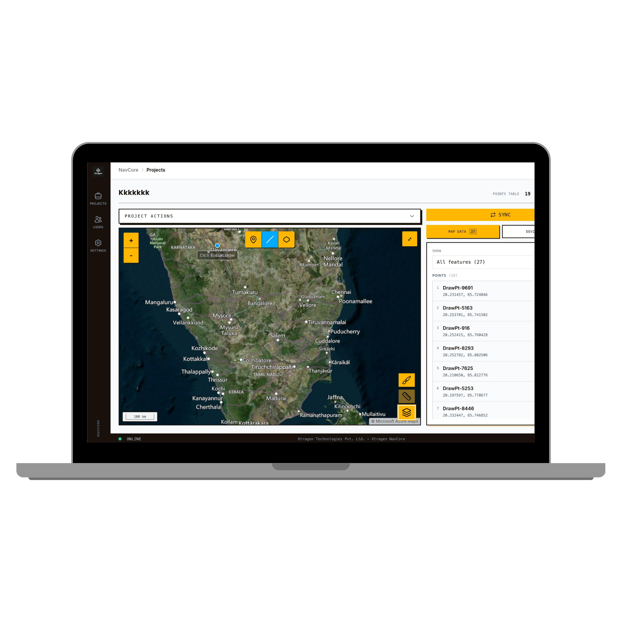
A powerful cloud portal that bridges the gap between field operations and central command.
Xtragen NavCore allows supervisors to monitor multiple operators simultaneously, instantly access any online unit, and coordinate field activities without relying on manual communication.
Its live tracking view shows active field devices on the project map in real time. Latitude, longitude, fix status, and device information update continuously while crews operate in the field. The platform also centralizes project data, survey points, users, devices, and licenses for defense, aerospace, and industrial navigation teams.
Xtragen NavCore is compatible with XT-200 GNSS Receiver and XT-Survey, allowing teams to connect field devices, Android survey workflows, and cloud-based project monitoring in one connected ecosystem.
Compatible with XT-200 and XT-Survey
NavCore works together with the XT-200 GNSS Receiver and XT-Survey Android application to support real-time device tracking, GNSS survey workflows, project monitoring, user management, and field team coordination.
Core Platform Features
Everything you need to command and control your GNSS and navigation deployments.
Real-Time Device Tracking
Track hardware deployments instantly across all active operations and sites.
Live Location Monitoring
Receive precise, continuous geographic positioning updates from the field.
GNSS Fix Status Visibility
Verify RTK stability, satellite count, and signal integrity remotely.
Project Management
Centralize your waypoints, operational maps, and field logs securely.
User Administration
Control access protocols and permissions for multi-tier technical teams.
License Management
Deploy, manage, and revoke hardware/software licenses from the cloud.
Multi-Operator Supervision
Oversee multiple concurrent surveying tasks and teams effortlessly.
One-Click Device Access
Instantly transition to view individual device telemetry and status.
How NavCore Works
A seamless bridge between field operations and central command.
Step 1
Field Device Connects
The operator connects their GNSS hardware to the NavCore cloud portal via the XT Survey app.
Step 2
GNSS Data Upload
Precision coordinates and telemetry transmit continuously to the cloud.
Step 3
Live Tracking Updates
The portal interface reflects device positioning and fix status instantly.
Step 4
Supervisor Monitoring
The command center gains complete visibility over the entire operation map.
Step 5
Team Coordination
Supervisors coordinate field activities seamlessly without relying on manual check-ins.
Step 6
Project Data Management
Survey points and logs are securely centralized and exported for analysis.
Platform Benefits
Real-Time Operational Visibility
Eliminate blind spots with continuous telemetry from all active field assets.
Faster Field Coordination
Direct operators instantly based on precise, live geographic mapping.
Centralized Project Management
Unify points, maps, and mission protocols in one single secure interface.
Better Resource Allocation
Deploy hardware and personnel efficiently based on live mission analytics.
Improved Decision Making
Act on high-fidelity, real-time GNSS data rather than delayed field reports.
License & User Control
Maintain strict access protocols and provisioning from the admin console.
Scalable Team Management
Seamlessly handle expansion from small squads to national deployment fleets.
Enterprise-Level Security
Defense-grade protection for mission-critical positioning data.
Frequently Asked Questions
What is Xtragen NavCore?+
Xtragen NavCore is a centralized cloud portal engineered for GNSS survey and PNT project management, allowing supervisors to oversee field devices and operations remotely.
How does live tracking work?+
Field devices sync their telemetry—including precise latitude, longitude, and fix status—to the NavCore platform continuously, mapping assets on the project dashboard in real time.
Can multiple operators be monitored simultaneously?+
Yes. The platform is designed to scale, allowing command centers to monitor entire fleets of field operators at once, while retaining the ability to drill down to individual device metrics instantly.
Does NavCore support GNSS survey workflows?+
Absolutely. It centralizes project data, survey points, and waypoints natively, bridging the gap between field surveying activities and backend data management.
Can administrators manage licenses?+
Yes. NavCore provides robust administrative tools to manage operational licenses, user access protocols, and provisioning directly from the cloud console.
Which industries use NavCore?+
It is built for high-reliability sectors, primarily serving Defense Operations, Aerospace Programs, Industrial Navigation, Surveying, and Critical Infrastructure development.
Start Managing Survey Operations with Xtragen NavCore
Access the cloud portal and Android application to manage GNSS survey operations, monitor devices, and coordinate navigation projects from a centralized platform.